


Forecasters say a cold front will move over northern Brazil during the first weekend of the year, bringing a greater chance of heavy rain and thunderstorms to several states in the Amazon basin. The weather service Climatempo highlights an elevated risk of intense downpours and severe storms across parts of Pará and Tocantins, while other northern areas will see clearer skies.
Impact of the Brazil cold front
Climatempo reports that the northwest of Pará, northeast of Amazonas and the state of Roraima should experience more sunshine and a reduced probability of rain over the weekend. By contrast, the southern and north-eastern sectors of Pará, much of Tocantins, Rondônia, Acre and large areas of Amazonas are expected to receive moderate to heavy rainfall.
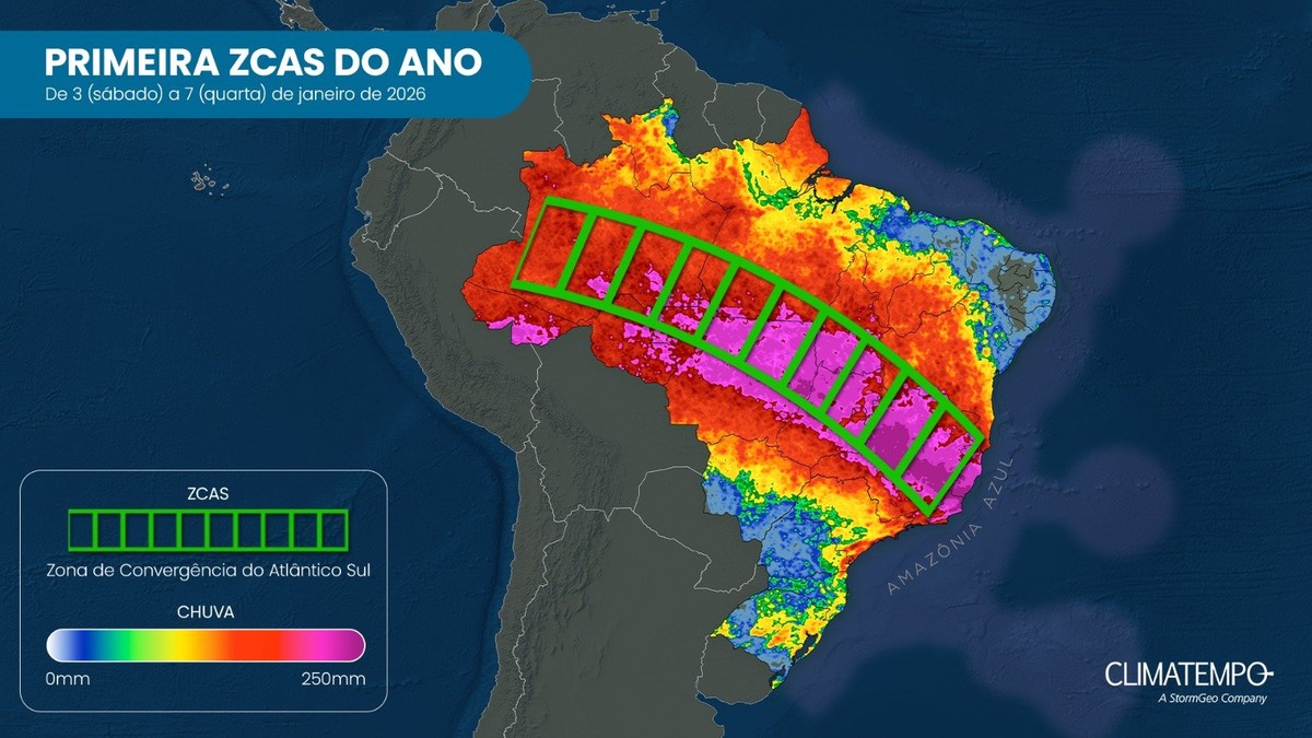
Authorities emphasise that the southern and south-eastern regions of Pará and stretches of Tocantins face the highest risk of temporals—intense thunderstorms capable of producing strong winds, heavy downpours and localised flooding. The meteorological pattern known as the South Atlantic Convergence Zone (ZCAS) is contributing to persistent cloud bands and enhanced instability in these areas.

Residents and visitors in the affected states should prepare for sudden changes in conditions. Heavy rainfall over short periods can overwhelm drainage systems, increase the chance of flash flooding and raise the risk of fallen trees and power outages. Road and air travel may be disrupted, and low-lying communities should be alert to warnings from local civil defence authorities.
In the northernmost state of Amapá, forecasters also expect moderate to heavy showers. Overall humidity will remain high and temperatures are likely to feel oppressive across much of the region, despite the influence of the cold front in certain pockets.
Local governments typically issue guidance ahead of events like this, advising people to secure outdoor objects, avoid travel in flooded areas and monitor official channels for weather alerts. Operators of public services, including transport and utilities, often put contingency plans into effect in response to severe-weather forecasts.
Meteorologists note that the behaviour of the ZCAS can change rapidly, so predictions carry some uncertainty. Users of the information should check updated forecasts frequently, particularly if they live in the high-risk zones identified for intense storms. Emergency services remain on standby in several municipalities, ready to respond should conditions deteriorate.
For those in areas predicted to remain drier—northwest Pará, northeast Amazonas and Roraima—the weekend will offer a respite from the widespread clouds and rain seen in recent days. However, with the region-wide humidity still significant, showers cannot be ruled out entirely.
Climatempo’s bulletin underlines the mixed picture: some pockets will benefit from clearer skies, while others face heavy rainfall and storm risks associated with the Brazil cold front and the ZCAS. Residents are advised to follow updates and heed instructions from local authorities until the system moves away and conditions stabilise.
Key Takeaways:
- A cold front will influence northern Brazil this first weekend of the year, raising the chance of heavy rain and thunderstorms across parts of the Amazon and Pará.
- Forecasters from Climatempo warn of moderate to intense downpours and a heightened risk of severe storms in southern and southeastern Pará and in Tocantins.
- Regions including northwest Pará, northeast Amazonas and Roraima should see more sun and lower rain chances, while other areas remain humid and sweltering.


