


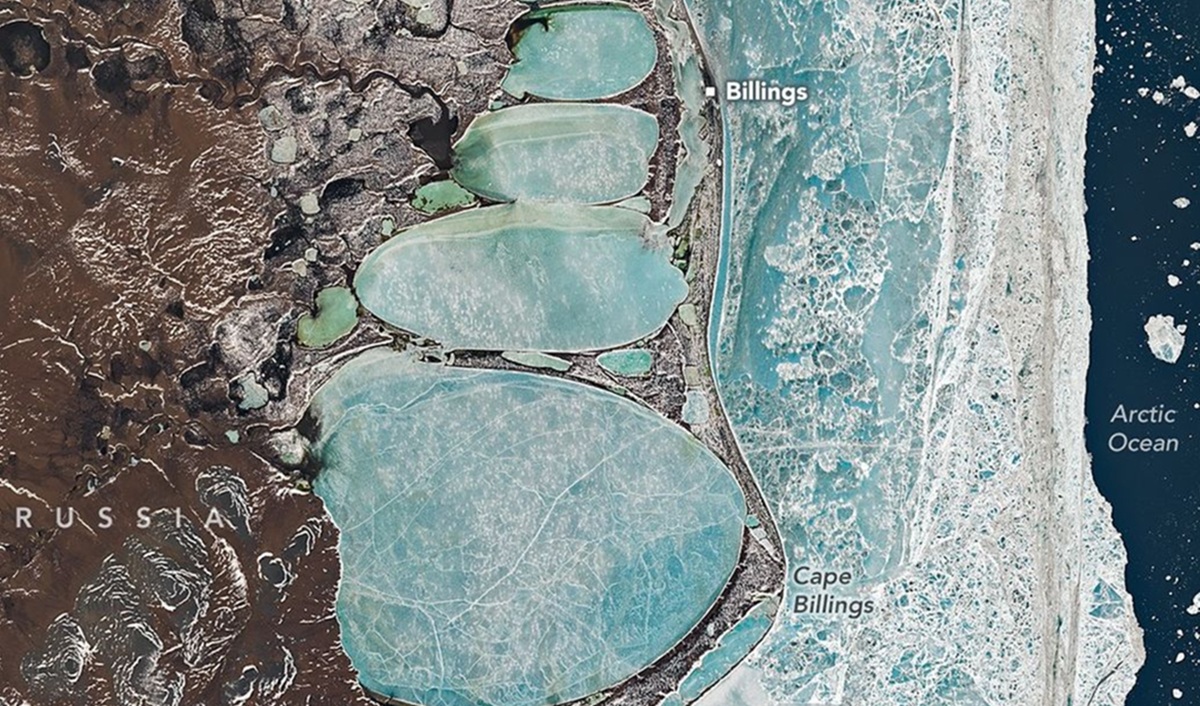
A striking satellite image from NASA shows a 22-kilometre snowman-shaped formation of frozen lagoons along the Billings coast of Russia’s Chukchi Peninsula. The image, acquired on 16 June 2025 by the Landsat 8 spacecraft, reveals a sequence of oval lagoons arranged in a pattern that, from orbit, resembles a giant figure clinging to the shoreline.
Snowman-shaped formation captured by Landsat 8
Although visually arresting, the feature is not artificial. Scientists say it is a natural consequence of coastal geomorphology in what NASA describes as a geomorphic “edge zone” where land, ice, water and wind continuously reshape one another. The frozen lagoons extend roughly 22 km from top to bottom. By comparison, the tallest human-made snowman on record stood at only 37.21 metres.
The Billings area was established in the 1930s as a Soviet port and occupies a narrow strip of land separating the Arctic Ocean from a string of connected coastal lagoons. Even though June is typically the warmest month in this sector of the Arctic, the landscape in the image remains locked in ice. NASA reported that daily minimum temperatures around mid-June averaged about -0.6°C, conditions that support persistent seasonal sea ice and frozen lagoons.

How the image was made
The photograph was taken by the Operational Land Imager (OLI) aboard Landsat 8, a low-Earth orbit satellite that has been monitoring Earth since its launch in February 2013. OLI records reflected sunlight across visible to shortwave infrared wavelengths and produces multispectral images with 27-metre resolution; a separate panchromatic band offers sharper 13-metre detail. These capabilities make Landsat 8 well suited for mapping extensive coastal areas and tracking changes over time.
Beyond the novelty of the snowman-shaped formation, the image delivers valuable scientific information about permafrost and coastal dynamics. Researchers can use such imagery to compare ice cover, lagoon extent and shoreline configuration from season to season and year to year. Consistent data streams from satellites like Landsat 8 are essential for detecting gradual environmental shifts that affect erosion, ecosystem habitat and local human activity.
Scientific value and context
Images such as this help scientists to monitor the persistence of seasonal ice and to understand how Arctic coasts respond to warming and mechanical forces from wind and waves. The frozen lagoons captured in mid-June represent a snapshot in time: in some years they may thaw earlier, exposing different patterns of water, sediment and vegetation. Long-term, comparable satellite records allow researchers to quantify such changes reliably.
While the giant snowman is a pleasing optical coincidence for viewers, its importance is practical. It highlights the continuing role of Earth observation satellites in documenting physical processes in remote regions, supporting research into permafrost stability and coastal evolution at high latitudes. As the Arctic continues to experience climatic shifts, maintaining a consistent satellite record remains a priority for scientists studying the region.
Image credit: NASA Landsat 8 / Space/Z-2
Key Takeaways:
- NASA’s Landsat 8 captured a 22 km snowman-shaped formation of frozen lagoons near Billings on the Chukchi Peninsula.
- The image highlights Arctic coastal dynamics, permafrost persistence and seasonal sea-ice interactions in mid-June conditions.
- Landsat 8’s OLI instrument provides multispectral data at 27 m (and 13 m panchromatic) resolution useful for long-term monitoring.


